
Nigeria LandMass by State: If you’re a Nigerian, then there is a need to know the biggest Nigerian state by LandMass and the smallest. Before proceeding, Here’s a related Fun Fact: The second (2nd) smallest state in Nigeria by LandMass is Anambra State.
Want to know everything about Nigeria’s state landmass? Then this article can become a source of extremely valuable information for you.
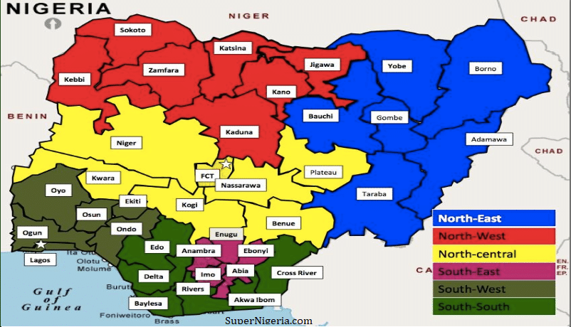
Landmass of Nigeria.

Nigeria geopolitical zones and States described in this image.
Before anything, you should know that the Federal Republic of Nigeria is divided into states (which is thirty-six (36) in total), including a Federal Capital Territory. All the states, in turn, has 774 Local Government Areas (LGA).
Although it is not official, the 36 states of Nigerian consist of 6 zones, namely:
South-West Zone:
- Lagos state,
- Ekiti state,
- Ogun state,
- Ondo state,
- Osun state,
- Oyo state.
South Zone:
- Akwa-Ibom,
- Bayelsa,
- Cross river,
- Delta,
- Edo,
- Rivers.
South-East Zone:
- Abia,
- Anambra,
- Ebonyi, Aguno,
- Imo State.
Northwest Zone:
- Kaduna,
- Kano,
- Katsina,
- Jigawa,
- Kebbi,
- Sokoto,
- Zamfara.
North-Central Zone:
- Benue,
- Kogi,
- Kwara,
- Nasarawa,
- Niger,
- Plateau.
North-East Zone:
- Adamawa,
- Bauchi,
- Borno,
- Gombe,
- Taraba,
- Yobe.
Take note that the capital of Nigeria is Abuja. ABUJA has the status of Federal capital territory, though, and does not belong to any state, which means it stands on its own.
After Nigeria got her independence in the year 1960, Nigeria had only three regions, which are:
- Northern Region (This region comprises of the center in Kaduna and Hausa as a main dominated nation),
- West Region (its center is located in Ibadan, capital of Oyo State and it is mainly populated by the Yoruba nation).
- East Region (This region center is situated in Enugu. The major nations which occupy this territory are Igbo, Edo (Bini), and Ibibio).
Seven years (7) after independence, which is in 1967, things started changing, the region was transformed into 12 States. Within a few years, Nigeria no longer has regions, but states.
NIGERIA’S 36 STATES & FCT RANKED IN ORDER OF LAND SURFACE AREA (KM²)
1. Niger State 76,363KM²
2. Borno State 70,898KM²
3. Taraba State 54,473KM²
4. Kaduna State 46,053KM²
5. Bauchi State 45,837KM²
6. Yobe State 45,502KM²
7. Zamfara State 39,762KM²
8. Adamawa State 36,917KM²
9. Kwara State 36,825KM²
10. Kebbi State 36,800KM²
11. Benue State 34,059KM²
12. Plateau State 30,913KM²
13. Kogi State 29,833KM²
14. Oyo State 28,454KM²
15. Nasarawa State 27,117KM²
16. Sokoto State 25,973KM²
17. Katsina State 24,192KM²
18. Jigawa State 23,154KM²
19. Cross River State 20,156KM²
20. Kano State 20,131KM²
21. Gombe State 18,768KM²
22. Edo State 17,802KM²
23. Delta State 17,698KM²
24. Ogun State 16,762KM²
25. Ondo State 15,500KM²
26. Rivers State 11,077KM²
27. Bayelsa State 10,773KM²
28. Osun State 9,251KM²
29. Federal Capital Territory 7,315KM²
30. Enugu State 7,161KM²
31. Akwa Ibom State 7,081KM²
32. Ekiti State 6,353KM²
33. Abia State 6,320KM²
34. Ebonyi State 5,670KM²
35. Imo State 5,530KM²
36. Anambra State 4,844KM²
37. Lagos State 3,345KM²
- Anambra + Enugu + Abia + Imo + Ebonyi = 29,525KM²
While only Kogi State has a landMass of 29,833KM².
- Ogun + Oyo + Osun + Ondo + Ekiti = 76,320KM²
While Niger state alone has an amazing landmass of 76,363KM². This means that Niger State landmass, covers the entire Southwest States, except Lagos State. Lagos state has a landmass of 3,345KM².
The entire Southeast is a little less than Kogi State only.
NIGERIA LAND MASS BY STATES:
For your information, the smallest state in Nigeria by landMass is Lagos.
Lagos State Landmass.
Lagos State is situated on the shores of the Gulf of Benin and Lagos lagoon, this city covers almost the entire territory of the eponymous state.
Although this state has the smallest Landmass in Nigeria, it consists of a large number of areas that are scattered at large distances and are connected by highways.
Another Fun Fact is that although it’s the smallest, Lagos State is the largest industrial and commercial center of West Africa, not just Nigeria alone.
Lagos state has the greatest density of population all over Nigeria, which means it’s overpopulated.
Lagos landmass reaches 3 345 km.
The second smallest state in Nigeria is Anambra.
Anambra is a state located in Southern Nigeria. By LandMass, Anambra is one of Nigeria’s smallest states (35th place out of 36 states).
The administrative center of the state is the city of Awka, which is also the Capital of the city. The major cities of Anambra are Onitsha and Nnewi. The state is named in honor of the river, Anambra.
Kano State LandMass.
This may be surprising to many people, especially Citizens of Nigeria who thought they know better. Kano is the second most crowded state of Nigeria and is the economic center of the Northern part of Nigeria.
Kano state is a major trading center of cotton, cattle, and peanuts. The best place to buy extremely high-quality leather and dyed goatskin in North Africa is Kano state.
Most products from the state are taken to Europe, where such materials are called Moroccan leather. Kano state land mass is 20,131 km2.
Kwara State Landmass.
Kwara is a state in Nigeria, while Ilorin is the Capital. This state is situated 306 km to the northeast of Lagos and 500km southwest of Abuja.
Kwara state landmass is 36 825 km2. In comparison to other states in LandMass, Kwara is the 9th largest state in Nigeria.
Ibadan LandMass.
Ibadan is a city which is located in the south-West region of Nigeria. The Capital city of Oyo state. Ibadan is the third-largest city in the country in terms of population, taking third (3rd) position after Lagos and Kano.
The number of population in Ibadan are more than 2.5 million residents. It is mostly inhabited by the Yoruba nation.
Abuja LandMass.
What is the Landmass of FCT Abuja? For those who might not be aware, Abuja was made Nigeria’s capital on the 12th of December, 1991. Before Abuja was made Nigeria’s capital, the capital of Nigeria was Lagos State. Abuja is located just 800 km to the North of Lagos.
FCT Abuja is where Aso Rock is, the official residential Area of the Nigerian President and government, political-administrative and cultural center of the country.
The decision to move the capital of Nigeria from Lagos to Abuja was made in the year 1976. However, Lagos state, which is the former capital of Nigeria, remains the major economic center of the country even after the Capital was removed.
Abuja has a population of about 778 567 inhabitants, which is increasing at a very fast rate. Abuja is situated within the area of the Federal Capital Territory. Abuja’s landmass is 1,769 km2.


Leave a Comment